Portal:Rhode Island/Selected picture

Coordinates: 41°22′45″N 71°38′43″W / 41.3792677°N 71.6453401°W / 41.3792677; -71.6453401
From Wikipedia, the free encyclopedia

Selected picture

If you wish to add an image for rotation within this portal, please

  • Add the image in to a subpage of this portal, such as Portal:Rhode Island/Selected picture/#, replacing the "#" with the number above the current highest. For example, if 20 pictures are in rotation, you would make the number of the picture you are creating 21.
  • Update the picture maximum limit parameter on the main Portal
  • Fair use images which are not released under a free-license (i.e. Public Domain, GNU Free Documentation License) will be removed on sight.
  • Update this list accordingly

Portal:Rhode Island/Selected picture/1
The 50 State Quarters program (Pub. L.Tooltip Public Law (United States) 105–124 (text) (PDF), 111 Stat. 2534, enacted December 1, 1997) is the release of a series of commemorative coins by the United States Mint. Between 1999 and 2008, it featured each of the 50 individual U.S. states on unique designs for the reverse of the quarter.
Credit: United States Government

The 50 State Quarters program (Pub. L.Tooltip Public Law (United States) 105–124 (text) (PDF), 111 Stat. 2534, enacted December 1, 1997) is the release of a series of commemorative coins by the United States Mint. Between 1999 and 2008, it featured each of the 50 individual U.S. states on unique designs for the reverse of the quarter.

More selected pictures


Portal:Rhode Island/Selected picture/2
Brown University is a private university and member of the Ivy League located in Providence, Rhode Island. It was founded as the College in the English Colony of Rhode Island and Providence Plantations in 1764, prior to American independence from the British Empire and early in the reign of King George III (1760–1820). Brown is the third-oldest institution of higher education in New England and seventh oldest in the United States.
Credit: User:Dale182

Brown University is a private university and member of the Ivy League located in Providence, Rhode Island. It was founded as the College in the English Colony of Rhode Island and Providence Plantations in 1764, prior to American independence from the British Empire and early in the reign of King George III (1760–1820). Brown is the third-oldest institution of higher education in New England and seventh oldest in the United States.

More selected pictures


Portal:Rhode Island/Selected picture/3
Waterplace Park is an urban park situated in downtown Providence, Rhode Island, finished in 1994. It is connected to 3/4 miles of cobblestone-paved pedestrian walkways along the waterfront known as Riverwalk.
Credit: User:Loodog

Waterplace Park is an urban park situated in downtown Providence, Rhode Island, finished in 1994. It is connected to 3/4 miles of cobblestone-paved pedestrian walkways along the waterfront known as Riverwalk.

More selected pictures


Portal:Rhode Island/Selected picture/4
Newport is a city on Aquidneck Island in Newport County, Rhode Island, United States, about 30 miles (48 km) south of Providence. It is known as a New England summer resort and famous for the Newport Mansions; it is also the home of Salve Regina University and Naval Station Newport, which houses the United States Naval War College, the Naval Undersea Warfare Center, and a major United States Navy training center.
Credit: Kyle Anderson

Newport is a city on Aquidneck Island in Newport County, Rhode Island, United States, about 30 miles (48 km) south of Providence. It is known as a New England summer resort and famous for the Newport Mansions; it is also the home of Salve Regina University and Naval Station Newport, which houses the United States Naval War College, the Naval Undersea Warfare Center, and a major United States Navy training center.

More selected pictures


Portal:Rhode Island/Selected picture/5
The Newport Casino is located at 186-202 Bellevue Avenue, Newport, Rhode Island, United States. It was designated a National Historic Landmark on February 27, 1987.
Credit: User:Daniel Case

The Newport Casino is located at 186-202 Bellevue Avenue, Newport, Rhode Island, United States. It was designated a National Historic Landmark on February 27, 1987.

More selected pictures


Portal:Rhode Island/Selected picture/6
The Breakers is a Vanderbilt mansion located on the Atlantic Ocean at Ochre Point Avenue, Newport, Rhode Island, United States. It is a National Historic Landmark and a contributing property to the Bellevue Avenue Historic District, and is owned and operated by the Preservation Society of Newport County.
Credit: Wadester16

The Breakers is a Vanderbilt mansion located on the Atlantic Ocean at Ochre Point Avenue, Newport, Rhode Island, United States. It is a National Historic Landmark and a contributing property to the Bellevue Avenue Historic District, and is owned and operated by the Preservation Society of Newport County.

More selected pictures


Portal:Rhode Island/Selected picture/7
The Mount Hope Bridge is a two-lane suspension bridge spanning the Mount Hope Bay in eastern Rhode Island, at one of the narrowest gaps in Narragansett Bay. The bridge connects the Rhode Island towns of Portsmouth and Bristol, and is part of Route 114.
Credit: User:Voyager

The Mount Hope Bridge is a two-lane suspension bridge spanning the Mount Hope Bay in eastern Rhode Island, at one of the narrowest gaps in Narragansett Bay. The bridge connects the Rhode Island towns of Portsmouth and Bristol, and is part of Route 114.

More selected pictures


Portal:Rhode Island/Selected picture/8
Watch Hill is an exclusive coastal village in the southwestern section of the town of Westerly, and the most southwestern town in the U.S. state of Rhode Island. Watch Hill is a state-chartered Fire District (1901) and is authorized to tax residents to fund their volunteer fire department, but the bulk of property taxes goes to the town to fund municipal services and schools.
Credit: User:Daniel Case

Watch Hill is an exclusive coastal village in the southwestern section of the town of Westerly, and the most southwestern town in the U.S. state of Rhode Island. Watch Hill is a state-chartered Fire District (1901) and is authorized to tax residents to fund their volunteer fire department, but the bulk of property taxes goes to the town to fund municipal services and schools.

More selected pictures


Portal:Rhode Island/Selected picture/9
Jerimoth Hill is the highest natural point in the U.S. state of Rhode Island, at 812 feet (247 m) above sea level. It was formerly controversial due to property complications, but it is now accessible to the public on weekends.
Credit: User:Khoule23

Jerimoth Hill is the highest natural point in the U.S. state of Rhode Island, at 812 feet (247 m) above sea level. It was formerly controversial due to property complications, but it is now accessible to the public on weekends.

More selected pictures


Portal:Rhode Island/Selected picture/10
The Ocean Drive Historic District covers Ocean Drive along the southern shore of Newport, Rhode Island, United States. It was designated a National Historic Landmark District in 1976 and consists of houses on large lots that overlook the beaches and ocean.
Credit: User:Daniel Case

The Ocean Drive Historic District covers Ocean Drive along the southern shore of Newport, Rhode Island, United States. It was designated a National Historic Landmark District in 1976 and consists of houses on large lots that overlook the beaches and ocean.

More selected pictures


Portal:Rhode Island/Selected picture/11
Doyle Avenue Historic District is a historic district which extends along Doyle Avenue from North Main Street to Hope Street in Providence, Rhode Island. The district features late 19th and early 20th century revivals and late-Victorian architecture, and it was added to the National Register of Historic Places in 1990.
Credit: User:Marcbela

Doyle Avenue Historic District is a historic district which extends along Doyle Avenue from North Main Street to Hope Street in Providence, Rhode Island. The district features late 19th and early 20th century revivals and late-Victorian architecture, and it was added to the National Register of Historic Places in 1990.

More selected pictures


Portal:Rhode Island/Selected picture/12
The Newport Cliff Walk is considered one of the top attractions in Newport, Rhode Island. It is a 3.5-mile (5.6 km) public access walkway that borders the shore line, and it has been designated a National Recreation Trail.
Credit: User:Jferro67

The Newport Cliff Walk is considered one of the top attractions in Newport, Rhode Island. It is a 3.5-mile (5.6 km) public access walkway that borders the shore line, and it has been designated a National Recreation Trail.

More selected pictures


Portal:Rhode Island/Selected picture/13
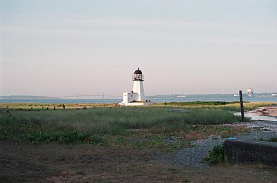
The Prudence Island Lighthouse (known locally as the Sandy Point Lighthouse) is located on Sandy Point, Prudence Island, Rhode Island and is the oldest lighthouse tower in the state. Sandy Point is nicknamed Chibacoweda, meaning "little place separated by a passage," because the location is a little more than one mile offshore.
Credit: User:Juni0r75

The Prudence Island Lighthouse (known locally as the Sandy Point Lighthouse) is located on Sandy Point, Prudence Island, Rhode Island and is the oldest lighthouse tower in the state. Sandy Point is nicknamed Chibacoweda, meaning "little place separated by a passage," because the location is a little more than one mile offshore.

More selected pictures


Portal:Rhode Island/Selected picture/14
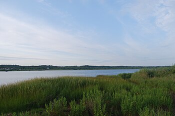
Winnapaug Pond (also known as Brightman Pond) is a breached saltwater pond in Westerly, Rhode Island, United States, connected to Block Island Sound by the Weekapaug Breachway, which was constructed during the mid-1950s. The 2.5-mile (4.0 km) long lake is separated from the Atlantic by a large sandbar.
Credit: User:Juliancolton

Winnapaug Pond (also known as Brightman Pond) is a breached saltwater pond in Westerly, Rhode Island, United States, connected to Block Island Sound by the Weekapaug Breachway, which was constructed during the mid-1950s. The 2.5-mile (4.0 km) long lake is separated from the Atlantic by a large sandbar.

More selected pictures


Portal:Rhode Island/Selected picture/15
Misquamicut State Beach is a state park that stretches 7 miles from Weekapaug in the east westward to Watch Hill. Misquamicut is in southern Washington County and is part of the town of Westerly.
Credit: User:Juliancolton

Misquamicut State Beach is a state park that stretches 7 miles from Weekapaug in the east westward to Watch Hill. Misquamicut is in southern Washington County and is part of the town of Westerly.

More selected pictures


Portal:Rhode Island/Selected picture/16
Misquamicut Beach is a beach that stretches 7 miles from Weekapaug in the east, westward to Watch Hill. Misquamicut is in southern Washington County and is part of the town of Westerly.
Credit: User:Juliancolton

Misquamicut Beach is a beach that stretches 7 miles from Weekapaug in the east, westward to Watch Hill. Misquamicut is in southern Washington County and is part of the town of Westerly.

More selected pictures


Portal:Rhode Island/Selected picture/17
Ninigret Pond is a coastal lagoon in Charlestown, Washington County, Rhode Island, United States, located at 41°22′45″N 71°38′43″W / 41.3792677°N 71.6453401°W / 41.3792677; -71.6453401. It is the largest of nine such lagoons (often referred to as "salt ponds") in southern Rhode Island.
Credit: User:Juliancolton

Ninigret Pond is a coastal lagoon in Charlestown, Washington County, Rhode Island, United States, located at 41°22′45″N 71°38′43″W / 41.3792677°N 71.6453401°W / 41.3792677; -71.6453401. It is the largest of nine such lagoons (often referred to as "salt ponds") in southern Rhode Island.

More selected pictures


Portal:Rhode Island/Selected picture/18
Narragansett Bay is a bay and estuary on the north side of Rhode Island Sound covering 147 mi2 (380 km2). It forms New England's largest estuary, which functions as an expansive natural harbor and includes a small archipelago.
Credit: flickr

Narragansett Bay is a bay and estuary on the north side of Rhode Island Sound covering 147 mi2 (380 km2). It forms New England's largest estuary, which functions as an expansive natural harbor and includes a small archipelago.

More selected pictures


Portal:Rhode Island/Selected picture/19
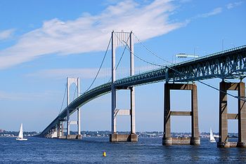
Claiborne Pell Newport Bridge is a suspension bridge operated by the Rhode Island Turnpike and Bridge Authority that spans the East Passage of the Narragansett Bay, connecting the City of Newport on Aquidneck Island and the Town of Jamestown on Conanicut Island. The bridge is four lanes (two in each direction) and is part of RI 138.
Credit: Wadester16

Claiborne Pell Newport Bridge is a suspension bridge operated by the Rhode Island Turnpike and Bridge Authority that spans the East Passage of the Narragansett Bay, connecting the City of Newport on Aquidneck Island and the Town of Jamestown on Conanicut Island. The bridge is four lanes (two in each direction) and is part of RI 138.

More selected pictures


Portal:Rhode Island/Selected picture/20
The Rose Island Light (built 1870) is located on Rose Island in Narragansett Bay in Newport, Rhode Island in the United States. The Rose Island Lighthouse Foundation preserves, maintains, and operates the lighthouse.
Credit: Juliancolton

The Rose Island Light (built 1870) is located on Rose Island in Narragansett Bay in Newport, Rhode Island in the United States. The Rose Island Lighthouse Foundation preserves, maintains, and operates the lighthouse.

More selected pictures